Craftsmen in New Jersey
|
The mapping component of this project remains a work in progress. The goal of the map is to reveal discrete areas of industry not previously recognized by historians of early colonial craftsmanship through visualizing the working locations of craftsmen. This data set was identified in Appendix A of my MA thesis, United by Water: Cabinetmaking Traditions in the Delaware Valley, 1670-1740. It is freely available for download via the link provided.
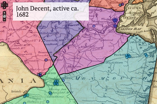
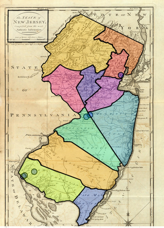
In 2014, I used Omeka and Neatline to create a test map that allowed for overlay of geographic reference points represented by blue dots (a sample of that map is shown at lower right). Hovering over each dot enabled a small pop-up window with brief information about each craftsman and dates active (sample seen at upper right). Clicking on the pop-up opened another window containing further biographical information. Each dot on the map will represent an individual craftsman who was identified (or self-identified) with a particular trade in land transactions, tax records, as well as estate and vital records. When complete, the density of reference points will identify seven major centers of woodworkers and--by extension--carpentry and furniture-making, controverting a long-held assumption that New Jersey had no furnituremakers, leaving its inhabitants to obtain furnishings from either Philadelphia or New York. The towns most densely populated by woodworkers (some of which are mapped at right) were primarily Burlington, Salem, Woodbridge, Newark, Freehold, The Amboys, and Newton (later Camden). Even areas of disparate settlement, like in Salem County, still had pockets of industry clustered adjacent to rivers, the main routes of transportation for all goods. A new version of the visualization will be created using an 18th-century map that contains more early place names found in period manuscript documents to improve the map's accuracy. The final active map will look similar to the one below with an overlay of counties to capture woodworkers who are not identified with a narrower geographic location, like a town. |
|
The majority of the information used to construct biographical information populated in this map came from sources included in the bibliography section. NJCW I. refers to the Calendar of New Jersey Wills, Administrations, etc. I. 1670-1730 (1901) and DP&OER NJ refers to the Calendar of Records in the Office of the Secretary of State, 1664-1703.
I am looking for ways to improve the mapping interface and welcome suggestions for other tools for mapping and visualization. Please share them in the comments section below.
I am looking for ways to improve the mapping interface and welcome suggestions for other tools for mapping and visualization. Please share them in the comments section below.
